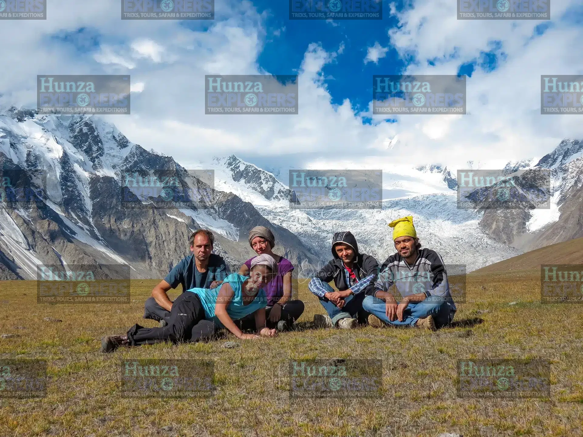
Patundas Meadows Trek: The Complete Trekking Guide to Upper Hunza, Pakistan
The Patundas Meadows Trek is one of the most rewarding short high-altitude trekking experiences in Upper Hunza, Gilgit-Baltistan, Pakistan. Situated in the mountains above Ghulkin and Passu in the Gojal region, Patundas is known for its expansive alpine pastures, impressive glacier landscapes and panoramic views of the Karakoram mountain range.
Reaching approximately 4,200 metres above sea level, the meadows offer an exceptional mountain experience for trekkers who want to explore beyond the main settlements and roads of Hunza Valley. The journey combines mountain trails, a crossing of Passu Glacier, high-altitude camping and beautiful summer landscapes.
The standard trekking programme takes three days, starting and finishing at Upper Borith. Along the way, trekkers pass through Kookhel and Lazdur before reaching the open pastures of Patundas Meadows.
The best time for the Patundas Meadows Trek is May to September. During this period, the route generally offers suitable conditions for trekking and camping, although snowfall, weather and glacier accessibility can affect the journey.
Whether you are an experienced trekker or a traveller looking for a challenging mountain adventure, Patundas offers an opportunity to experience the natural beauty of the Karakoram in a relatively short itinerary.
Patundas Meadows Trek at a Glance
| Trek Information | Details |
|---|---|
| Destination | Patundas Meadows |
| Country | Pakistan |
| Province | Gilgit-Baltistan |
| Region | Gojal, Upper Hunza |
| Mountain Range | Karakoram |
| Trek Duration | 3 days |
| Starting Point | Upper Borith |
| Finishing Point | Upper Borith |
| Highest Point | Approximately 4,200 metres |
| Main Glacier Crossing | Passu Glacier |
| Difficulty | Moderate to challenging |
| Best Season | May to September |
| Accommodation | Mountain camping |
| Trekking Type | High-altitude mountain trekking |
| Technical Climbing | Not normally required on the standard route |
| Local Guide | Strongly recommended |
| Nearest Settlements | Gulmit, Ghulkin, Borith, Hussaini and Passu |
Where Are Patundas Meadows?
Patundas Meadows are located in Gojal, Upper Hunza, within Gilgit-Baltistan in northern Pakistan. The meadows lie above the villages of Ghulkin and Passu, in a spectacular mountain landscape shaped by glaciers, high peaks and alpine pastures.
The area is part of the wider Karakoram mountain region and offers elevated views across the surrounding glaciers and mountains. The Passu Cones are among the most recognisable peaks in the landscape, while Passu Glacier and the surrounding mountain formations contribute to the area's distinctive scenery.
The usual trekking approach begins at Upper Borith, near Borith Lake. From there, the route leads towards Kookhel and Passu Glacier before climbing towards Lazdur and Patundas Meadows.
Unlike the more accessible attractions along the Karakoram Highway, Patundas can only be reached by trekking. Its remote location is one of the reasons the area remains attractive to people looking for a quieter mountain experience.
Why Visit Patundas Meadows?
Panoramic Views of the Karakoram
The mountain scenery is one of the main reasons to visit Patundas. Its elevated position provides wide views of the surrounding glaciers, peaks and valleys.
The impressive Passu Cones are among the highlights, while the wider landscape features the rugged mountain formations characteristic of the Karakoram.
Beautiful Alpine Pastures
During the summer trekking season, the meadows become green and colourful. The contrast between the open grasslands, rocky slopes, glaciers and snow-covered peaks creates a distinctive high-altitude landscape.
These pastures provide excellent opportunities for photography and spending time in the mountains.
Passu Glacier Crossing
The route includes a crossing of Passu Glacier, making the journey more varied than a conventional mountain trail.
Glacier surfaces are constantly changing. Crevasses, meltwater channels, loose stones and changing access conditions can affect the crossing. The route and crossing point must therefore be assessed by an experienced local trekking team.
A Three-Day Mountain Trek
The standard three-day itinerary makes Patundas an attractive option for travellers with limited time in Hunza who still want to experience a multi-day trek.
It combines different mountain environments without requiring a long expedition.
Camping Away from Settlements
Camping at Lazdur and Patundas allows trekkers to spend time in a remote mountain environment. The quiet surroundings, open landscapes and mountain views make camping an important part of the experience.
Best Time for the Patundas Meadows Trek
The best time for the Patundas Meadows Trek is May to September. These months generally provide suitable conditions for mountain trekking, alpine camping and exploring the higher pastures of Upper Hunza.
May
May marks the beginning of the trekking season. The lower mountain landscape starts becoming greener, while snow may remain on higher sections. The condition of the trail and glacier crossing should be checked before departure.
June
June is part of the main summer trekking period. Conditions generally become more favourable as the season progresses, and the alpine landscape begins to develop.
July
July is an excellent month for visiting Patundas. The summer landscape is generally greener, and the meadows offer an attractive setting for camping and photography.
August
August is another excellent month for the trek. It offers summer mountain scenery and opportunities to explore the surrounding alpine pastures.
September
September brings cooler temperatures and the changing colours of the mountain landscape. It can be an excellent month for trekking, although nights at higher elevations become colder.
Actual conditions can vary from year to year. Snowfall, rain, temperature and glacier accessibility can affect the route. Always confirm current conditions with the local trekking team before travelling.
How to Reach Upper Borith
Upper Borith is the starting point for the standard Patundas Meadows Trek. It is located in Gojal, Upper Hunza, near Borith Lake and the villages of Ghulkin and Passu.
Travellers normally reach Upper Hunza by road from Gilgit or other parts of northern Pakistan.
Islamabad to Hunza
The journey from Islamabad to Hunza can be completed by road or through a combination of domestic flights and road travel.
By Road
Travelling by road from Islamabad provides an opportunity to experience the changing landscapes of northern Pakistan. The journey follows the Karakoram Highway through areas such as Abbottabad, Besham, Chilas and Gilgit before continuing towards Hunza.
Travel duration depends on road conditions, traffic, weather and any temporary closures along the route. Travellers should allow sufficient time rather than planning the journey around an exact arrival hour.
By Air
Domestic flights between Islamabad and Gilgit can reduce road travel time when operating. However, flights are subject to weather conditions and operational schedules.
After arriving in Gilgit, travellers continue by road towards Hunza and Upper Borith.
Gilgit to Upper Borith
From Gilgit, the road journey continues north along the Karakoram Highway through the Hunza region.
Travellers pass through the main settlements of Hunza before continuing towards Gojal. Upper Borith is reached via the local road near Ghulkin.
The final approach to the trekking starting point should be arranged according to the condition of the access road and the group's transport requirements.
Travel arrangements should be confirmed before departure, particularly during periods of road maintenance, landslides or adverse weather.
Patundas Meadows Trek Route Explained
The standard route starts from Upper Borith and follows a mountain trail towards Kookhel. The route then crosses Passu Glacier before ascending towards Lazdur and Patundas Meadows.
The journey combines several types of terrain:
Upper Borith: The starting area near Borith Lake, with access to the initial trekking trail.
Kookhel: A section of the approach route before reaching the glacier crossing area.
Passu Glacier: A major feature of the trek. The crossing requires careful route selection and local guidance.
Lazdur: A mountain area used as a camping point on the route towards Patundas.
Patundas Meadows: The main destination, situated at approximately 4,200 metres above sea level.
The exact route and camping locations may vary according to glacier conditions, weather and the judgement of the local trekking team.
Three-Day Patundas Meadows Trek Itinerary
Day 1: Upper Borith to Kookhel and Lazdur
The trek begins at Upper Borith, near Borith Lake in Gojal, Upper Hunza. After meeting the local trekking team and preparing the equipment, the journey starts towards Kookhel.
The trail continues towards Passu Glacier, which forms an important part of the route. The glacier crossing requires care, as the surface and access conditions can change throughout the season. Trekkers should follow the instructions of their local guide and must not attempt the crossing independently.
After crossing the glacier, the route continues towards Lazdur. The landscape gradually changes as the trail climbs away from the glacier towards the mountain pastures.
Upon reaching the designated camping area, trekkers can rest and enjoy the surrounding mountain scenery.
Day 2: Lazdur to Patundas Meadows
After breakfast, continue the trek from Lazdur towards Patundas Meadows.
The trail climbs through the high-altitude mountain landscape, gradually opening towards the alpine pastures. As the elevation increases, views of the surrounding Karakoram peaks and glaciers become more impressive.
The final approach leads to Patundas, where the open meadows provide a beautiful setting surrounded by mountains.
Spend time exploring the surroundings, enjoying the views and photographing the landscape. Weather permitting, the area offers excellent opportunities for mountain photography and quiet exploration.
Day 3: Patundas Meadows to Upper Borith
Begin the return journey from Patundas towards Lazdur, following the same general route.
Continue towards Passu Glacier and cross it at a suitable point according to the advice of the local guide and current glacier conditions.
After crossing the glacier, follow the trail towards Kookhel and continue back to Upper Borith.
The trek concludes at the starting point, completing the three-day Patundas Meadows experience.
Itinerary note: The programme is a general route outline. Walking times, camping arrangements and the exact route may change according to weather, trail conditions, glacier accessibility and the pace of the group.
Trekking Distance and Altitude
The Patundas Meadows Trek follows a mountain route from Upper Borith through Kookhel and across Passu Glacier before ascending towards Lazdur and Patundas Meadows.
The destination lies at approximately 4,200 metres above sea level. The route involves sustained walking, changes in elevation and sections of uneven mountain terrain.
Daily walking requirements depend on the selected route, weather, glacier conditions, camping arrangements and the pace of the trekking group. Trekkers should be prepared for several hours of walking each day.
The three-day programme includes the approach to Lazdur, the ascent to Patundas Meadows and the return journey to Upper Borith.
Trek Difficulty and Physical Preparation
The Patundas Meadows Trek is generally considered moderate to challenging. Although technical climbing is not normally required on the standard route, the journey includes steep sections, uneven mountain trails, a glacier crossing and sustained walking at high altitude.
The difficulty depends on several factors:
Individual fitness and previous trekking experience.
Weather and ground conditions.
The condition of Passu Glacier.
The group's walking pace.
The amount of personal equipment being carried.
The altitude and individual response to it.
Trekkers should be comfortable walking for several hours on uneven terrain and carrying a daypack. Regular walking, hill training and cardiovascular exercise before the journey can help prepare the body.
Previous trekking experience is beneficial, particularly for travellers who have not walked on glaciers or at high elevations.
Is Patundas Suitable for Beginners?
Fit beginners with good preparation may be able to complete the trek with experienced local support. However, it should not be treated as an easy introductory walk.
The high altitude, glacier crossing and remote mountain environment require careful planning. People without previous trekking experience should discuss their fitness and expectations with the trekking operator before booking.
Altitude Awareness and Mountain Safety
Patundas Meadows are situated at approximately 4,200 metres above sea level. At this elevation, the reduced availability of oxygen can make physical activity more demanding.
Even fit and experienced trekkers can experience altitude-related symptoms.
Common symptoms of acute mountain sickness include:
Headache.
Nausea or loss of appetite.
Dizziness.
Unusual tiredness.
Difficulty sleeping.
Trekkers should ascend gradually, remain hydrated and inform their guide if they develop symptoms.
Severe or worsening symptoms require immediate medical attention and descent. A trekker suspected of having altitude illness should not be encouraged to continue ascending.
Patundas Meadows Trek for Acclimatisation Before K2
The Patundas Meadows Trek is also popular among trekkers preparing for longer and more demanding high-altitude expeditions in Pakistan, including K2 Base Camp and Gondogoro La. Reaching approximately 4,200 metres above sea level, the trek provides an opportunity to spend time at altitude and gain experience in the mountain environment of the Karakoram.
For international trekkers travelling to Pakistan for a major expedition, including Patundas in their travel programme can be a valuable way to introduce their bodies to higher elevations before proceeding to the Baltoro region.
The trek also provides practical experience of multi-day mountain walking, camping and trekking in remote terrain. These experiences can help participants prepare physically and mentally for the demands of a longer expedition.
However, acclimatisation varies between individuals and depends on the overall ascent profile, time spent at altitude and recovery. Patundas can form part of a wider acclimatisation itinerary, but trekkers should still follow an appropriate altitude plan for their subsequent expedition.
General Safety Preparation
Before departure:
Check the weather forecast and latest route conditions.
Confirm glacier accessibility with the local trekking team.
Carry suitable clothing and equipment.
Bring personal medication and a basic first-aid kit.
Follow the guide's instructions during the glacier crossing.
Avoid trekking alone in remote sections.
Allow flexibility in the schedule for changing conditions.
Passu Glacier Crossing
The Passu Glacier crossing is one of the most distinctive parts of the Patundas route. It introduces trekkers to the rugged glacial environment of the Karakoram.
Glaciers are dynamic landscapes. Their surfaces change with seasonal melting, snowfall and movement. Crevasses, unstable stones, meltwater channels and other hazards can affect the safest route.
The crossing point and method should be determined by an experienced local team after assessing the conditions.
Trekkers should not assume that a route used earlier in the season will remain safe later. Current conditions matter more than a fixed route description.
Appropriate footwear and any additional equipment required for the crossing should be confirmed before departure.
Camping at Patundas Meadows
Camping is an important part of the Patundas experience. The three-day itinerary generally includes camping at designated mountain locations along the route.
The mountain environment is remote, and facilities are limited. Trekkers should be prepared for basic outdoor camping rather than hotel-style accommodation.
Temperatures can fall significantly after sunset, even during the summer trekking season. A suitable sleeping bag, insulated clothing and appropriate camping equipment are essential.
The local trekking team should confirm which equipment is provided and what participants need to bring personally.
What to Expect at the Campsites
Trekkers should expect a natural mountain environment with limited facilities. Weather conditions, available flat ground and the judgement of the local team determine the exact camping arrangements.
There may be no permanent buildings, shops or reliable facilities along the route. All essential supplies should be organised before leaving the starting point.
Wildlife, Vegetation and Alpine Landscape
The landscape around Patundas changes with elevation and season. Lower sections of the route feature rocky mountain terrain and glacial landscapes, while higher areas open into alpine pastures.
During the summer months, the meadows become greener and may support seasonal mountain vegetation. The area provides a contrasting landscape of grasslands, rocky slopes, snow-covered peaks and glaciers.
Wildlife sightings in remote mountain areas can be unpredictable. Visitors should observe wildlife from a distance and avoid disturbing animals or their habitats.
What to Pack for the Patundas Meadows Trek
Packing the correct equipment is essential for a comfortable and safe high-altitude trekking experience.
Clothing
Moisture-wicking base layers.
Warm fleece or insulated mid-layer.
Waterproof and windproof outer jacket.
Trekking trousers.
Warm hat and gloves.
Comfortable trekking socks.
Lightweight clothing for warmer daytime conditions.
Footwear
Well-fitted trekking boots with good grip.
Spare trekking socks.
Gaiters, if required by current trail conditions.
Personal Equipment
Comfortable daypack.
Sleeping bag suitable for cold mountain temperatures.
Headlamp with spare batteries.
Sunglasses and sun protection.
Sunscreen and lip balm.
Reusable water bottle or hydration system.
Personal medication and basic first-aid supplies.
Power bank.
Camera equipment, if required.
Additional Equipment
The local trekking team should advise on any additional equipment required for the glacier crossing and camping arrangements.
Technical equipment requirements depend on the route conditions and the assessment made before departure. Do not assume that specialist equipment is unnecessary without first checking with the operator.
Local Guide and Porter Arrangements
Hiring an experienced local guide is strongly recommended for the Patundas Meadows Trek.
The route includes remote mountain trails and a glacier crossing, where conditions can change considerably. Local knowledge is particularly important when selecting the safest route and identifying suitable camping areas.
A local trekking team can assist with:
Route planning and navigation.
Assessment of glacier conditions.
Weather and trail monitoring.
Camping arrangements.
Coordination of porter support.
Advice on trekking equipment.
Assistance in managing the group's pace.
Porter arrangements depend on the group size, equipment requirements and the agreed trekking programme.
Travellers should clarify the porter allowance, personal luggage limits and equipment responsibilities before the trek begins.
Trek Cost and Booking Arrangements
The cost of the Patundas Meadows Trek depends on group size, travel dates, transportation requirements and the services included in the programme.
Private arrangements can include local trekking guides, porter support, camping equipment, meals and transportation, depending on the selected package.
Before booking, travellers should request a clear breakdown of the included services, equipment arrangements, transport, meals and any additional expenses.
Contact Hunza Explorers for a quotation based on your preferred dates, group size and trekking requirements. Our team can provide details of the available services and arrangements before booking.
Mobile Network and Connectivity
Mobile coverage in the mountains around Patundas should not be assumed. Connectivity may be limited or unavailable along parts of the route, particularly in remote sections and at higher elevations.
Travellers should inform family or friends about their trekking schedule before departure.
It is also advisable to download offline maps, keep important travel information available without an internet connection and carry a fully charged power bank.
The availability of mobile signals depends on the network provider, terrain and location. Confirm current coverage expectations with the local team rather than relying on connectivity throughout the trek.
Is the Patundas Meadows Trek Suitable for Families?
The trek may be suitable for physically fit adults and older teenagers with appropriate preparation, but it is not a casual family walk.
The high altitude, long walking days, glacier crossing and remote camping conditions need to be considered carefully.
Families travelling with children should discuss the route, individual fitness, previous trekking experience and safety requirements with the trekking operator before making arrangements.
The suitability of the trek should be assessed individually rather than based only on age.
Responsible Trekking in Upper Hunza
Patundas is a beautiful but fragile mountain environment. Visitors should minimise their impact throughout the journey and respect the natural landscape.
Carry all rubbish back from the trekking route.
Avoid damage to alpine plants and vegetation.
Do not disturb wildlife.
Use suitable camping locations.
Respect local communities and mountain practices.
Avoid unnecessary noise.
Follow the instructions of the local guide, especially during glacier crossings.
The local environment is an important part of the region's natural heritage. Responsible visitors help protect it for local communities and future generations.
Places to Visit Around Patundas and Upper Hunza
The Patundas trek can be combined with sightseeing in Hunza and Gojal. Before or after the trek, visitors can explore the villages, lakes, forts and mountain viewpoints of the region.
Borith Lake
Borith Lake is a beautiful high-altitude lake near Upper Borith and the starting area of the trek. It is a peaceful location surrounded by mountain scenery and is a convenient place to visit before or after the trekking programme.
Ghulkin Village
Ghulkin is a traditional village in Gojal, known for its mountain setting, local hospitality and access to several trekking routes. It is also one of the settlements associated with the Patundas trekking area.
Passu Village
Passu is famous for the spectacular Passu Cones and its impressive mountain landscape. The village is one of the most photographed destinations in Upper Hunza.
Attabad Lake
Attabad Lake is known for its striking turquoise water and surrounding mountains. It was formed following a major landslide in 2010 and has become one of the region's best-known visitor attractions.
Karimabad
Karimabad is a major destination in Central Hunza, offering access to historic forts, traditional settlements, local markets and views of the surrounding mountains.
Khunjerab Pass
Khunjerab Pass is located on the Pakistan-China border and is one of the highest paved international border crossings in the world. It is a popular excursion from Upper Hunza, subject to road and seasonal access conditions.
These destinations can be included in a wider Hunza itinerary depending on available time, road conditions and the traveller's interests.
Book Your Patundas Meadows Trek with Hunza Explorers
The Patundas Meadows Trek offers an opportunity to experience the alpine landscapes and mountain scenery of Upper Hunza in a three-day programme.
From the Passu Glacier crossing to the open meadows at approximately 4,200 metres, the route provides a rewarding mountain trekking experience for travellers who want to explore the Karakoram beyond the main tourist settlements.
Hunza Explorers organises trekking and travel programmes in Hunza and other mountain regions of Pakistan, working with local teams familiar with the terrain and conditions.
We can assist with route planning, local guides, camping arrangements, porter support and transport according to the agreed programme.
Explore our 3-Day Patundas Trek for a short mountain trekking experience or consider our Patundas Trek Expedition for a longer travel programme.
Contact our team with your preferred dates, group size and trekking requirements to discuss the available arrangements.
Frequently Asked Questions About the Patundas Meadows Trek
1. How many days are required for the Patundas Meadows Trek?
The standard itinerary takes three days, starting and finishing at Upper Borith in Gojal, Upper Hunza. The duration may change if weather or route conditions require adjustments.
2. What is the highest altitude of the Patundas Meadows Trek?
Patundas Meadows are located at approximately 4,200 metres above sea level. The exact elevation may vary depending on the location reached within the meadows.
3. When is the best time to trek to Patundas Meadows?
The best trekking season is May to September. These months generally offer suitable conditions for trekking and camping. Actual conditions depend on snowfall, weather and glacier accessibility.
4. How difficult is the Patundas Meadows Trek?
The trek is generally considered moderate to challenging. It includes steep mountain trails, sustained walking, high altitude and a glacier crossing. Good physical fitness and suitable trekking equipment are recommended.
5. Is the Patundas Meadows Trek safe?
The trek can be organised with appropriate preparation, experienced local support and careful assessment of weather and glacier conditions. However, it takes place in a remote high-altitude environment where risks cannot be eliminated. Trekkers should follow their guide's instructions and be prepared for changes to the itinerary.
6. Can I do the Patundas Trek without a guide?
An experienced local guide is strongly recommended. The route includes remote terrain and a glacier crossing, where local knowledge is important for navigation and safety.
7. Is previous trekking experience required?
Previous trekking experience is beneficial, particularly because of the high altitude and glacier crossing. Fit beginners may be able to complete the route with proper preparation and local support, but it should not be treated as an easy walk.
8. How much does the Patundas Meadows Trek cost?
The cost of the Patundas Meadows Trek depends on the selected departure date and package. Hunza Explorers regularly updates the available dates, prices and booking details on our trek page.
For the latest prices, scheduled departures and package information, visit our 3-Day Patundas Meadows Trek page.
9. Is camping equipment provided?
Yes. When you book the Patundas Meadows Trek with Hunza Explorers, we provide the camping equipment and necessary arrangements for the trek. This includes tents, sleeping mats, sleeping bags, cooking equipment and other essential camping supplies, so you can focus on enjoying the trekking experience without having to arrange the equipment yourself.
10. Is there mobile network coverage during the trek?
Mobile network coverage is limited along the Patundas trekking route. At Patundas Meadows, trekkers may need to walk a considerable distance to reach a spot where a mobile signal is available, and even then, reception is not guaranteed. This can be particularly important in an emergency. Trekkers should not rely on mobile phones as their only means of communication and should make appropriate arrangements with their local guide before starting the trek.
11. Can families do the Patundas Meadows Trek?
It may be suitable for physically fit adults and older teenagers with appropriate preparation. The high altitude, glacier crossing and remote camping conditions mean that suitability should be assessed individually, especially for children.
12. Is technical climbing required?
Technical mountaineering is not normally required on the standard trekking route. However, the glacier crossing and changing mountain conditions require careful assessment and guidance from an experienced local team.
13. Can Patundas be visited in winter?
Winter is not the recommended season. Snowfall, low temperatures and difficult access can make the route unsuitable. The recommended trekking season is May to September.
14. Can Patundas be used for acclimatisation before K2 Base Camp?
Yes. The Patundas Meadows Trek is a popular option for trekkers preparing for longer and more demanding high-altitude journeys in Pakistan, including K2 Base Camp and Gondogoro La. Reaching approximately 4,200 metres above sea level, it offers valuable time at altitude and an opportunity to prepare for the mountain environment of the Karakoram.
Including Patundas in a pre-expedition itinerary allows trekkers to gain experience with multi-day mountain walking, camping and remote mountain terrain before travelling to the Baltoro region. It can form a useful part of their overall acclimatisation and trekking preparation.
Individual responses to altitude vary, so the time spent at Patundas and the subsequent ascent should be considered within the wider expedition acclimatisation plan. Completing this trek does not automatically guarantee sufficient acclimatisation for K2 Base Camp or Gondogoro La.
15. Can I combine the Patundas Trek with a Hunza sightseeing tour?
Yes. The trek can be combined with visits to Borith Lake, Ghulkin, Passu, Attabad Lake, Karimabad and other destinations in Hunza, depending on the overall itinerary.
About the Author
Karim Ahmed Tajik is the Founder and CEO of Hunza Explorers, a destination management company specialising in trekking, mountain expeditions and cultural travel across Pakistan and neighbouring destinations.
Through Hunza Explorers, he works with local teams to develop travel and trekking programmes in the Karakoram and other mountain regions. His work focuses on regional knowledge, practical travel planning, responsible tourism and guest support.
The Patundas Meadows Trek is part of Hunza Explorers' trekking experiences in Upper Hunza, where local knowledge is essential for planning routes and responding to changing mountain conditions.
